
Finding Support
How far are NYC’s homelessness service access points from rail?
Independent mapping project · November 2026
How far are NYC’s homelessness service access points from rail?
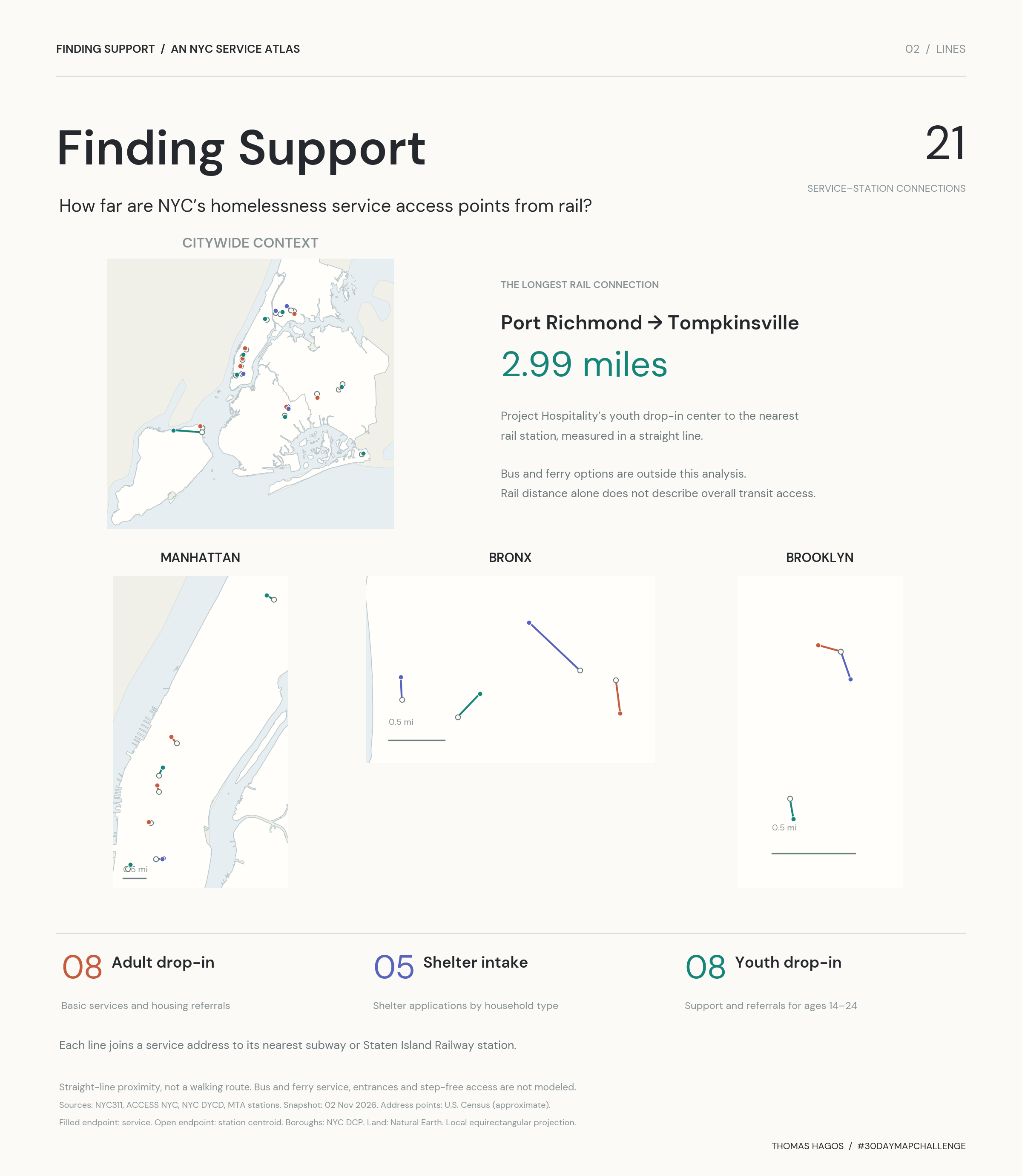
For this map, I brought together 21 publicly listed service access points: adult drop-in centers, shelter intake centers, and youth drop-in centers. I then connected each address to its nearest subway or Staten Island Railway station. The lines show straight-line distance, rather than walking routes.
Housing and public health are connected, and I wanted this project to focus on a practical question about where support is located. Close-up views of Manhattan, the Bronx and Brooklyn make the shorter connections visible, with a citywide overview for context. The map lets you filter by service type and borough, see who each location serves, and compare its distance from rail.
The map, scripts, saved data and outputs live in my separate map repository. This portfolio page links to that project.
What the lines show
Each connection runs from an approximate service address to the nearest MTA station centroid. I calculated the distances against all 496 station records in the saved MTA dataset, using the haversine formula.
The longest connection is the youth drop-in location in Port Richmond: approximately 2.99 miles from Tompkinsville on the Staten Island Railway. That is a rail-proximity measurement. Bus and ferry connections, actual street routes, station entrances and step-free access would be the next things to add.
Select a location to see the station name, approximate distance, hours, audience, and official service information.
Data and limits
The service directory comes from NYC311 adult drop-in listings, NYC311 shelter intake guidance, and NYC DYCD youth drop-in listings. Rail locations come from MTA Subway Stations, which includes Staten Island Railway.
This is a snapshot checked on November 2, 2026. It covers public service access points, rather than all shelters. The service coordinates are Census address interpolations; the lines are not verified walking paths. A shorter line does not establish that a service is easier to reach or that a bed is available. Check eligibility and hours through the official listing before travel.
Download the map image · Download the line data · Code and saved inputs
Tools, credits and design references
Made with Python, Matplotlib and Leaflet. Borough geometry: NYC Department of City Planning. Regional land: Natural Earth. Street context: OpenStreetMap contributors. Typography: DM Sans. Research, code and editing were assisted by AI. Design references include Work & Co’s MTA map and Morphocode’s Urban Layers.